Modeling particles reveals soil density impact on surface fault ruptures
The discrete element method models tens of millions of distinct particles to help understand this rare earthquake hazard and inform resilient civil engineering design.
The discrete element method models tens of millions of distinct particles to help understand this rare earthquake hazard and inform resilient civil engineering design.
Earthquakes can visibly and permanently crack the ground apart in dramatic and unpredictable surface fault rupture, but new research led by University of Michigan Engineering revealed that soil density strongly influences how and where they occur.
The research team, which includes collaborators at the U.S. Geological Survey (USGS), modeled soil as millions of particles interacting in order to represent the soil above a fault.
Explore the forefront of digital engineering
at Michigan Engineering
The first live video of surface fault rupture was captured in Myanmar in March 2025. Because of the absence of other real-time surface fault rupture videos, researchers rely on physical and virtual models to understand this rare hazard. But virtual models have been limited in the degree to which they reflect the behavior of physical sandbox models used in geology laboratory studies. To address that gap, the researchers leveraged the discrete element method, treating soil as a collection of distinct particles that interact more like real soil grains.
“Our goal is to quantify and anticipate how surface fault rupture will develop at the ground surface so we can accommodate the associated ground deformations in civil engineering design or retrofit whenever we cannot outright avoid the hazard,” said Estéfan Garcia, an assistant professor of civil and environmental engineering at U-M and corresponding author of the study published in the Journal of Geotechnical and Geoenvironmental Engineering.
A security video from a home’s front door in a rural area captures ground shaking and subsequent ground displacement following an earthquake.
Up to this point, most virtual models of surface fault rupture relied on the finite element method. This technique requires the researcher to encode strength and stiffness, and it treats soil as a continuous mesh. The discrete element method instead models soil closer to its true nature as a collection of distinct particles.
The discrete element method allows properties like strength and stiffness to emerge naturally from how particles interact based on Hooke’s Law and Newton’s Second Law. Together, these laws describe how forces result from particle contacts and lead to particle motions. This approach makes the virtual models more like virtual experiments for observing complex soil behavior from its fundamental origins in particle-to-particle interactions.
“The foundation is basic physics,” said Garcia. “I like that while the numerical integration and simulation programming are more complex, the underlying physics is based on principles taught to first- and second-year undergraduate students.”
Each virtual particle is a simplified shape made of three spheres, called elements, clumped together to ensure it cannot roll continuously like a ball or a cylinder. These simplified shapes represent key features of soil: soil grains are three-dimensional and non-spherical, and soil is a discontinuous collection of distinct particles.
Using the Frontera supercomputer at the Texas Advanced Computing Center, the researchers modeled soil as a collection of 1 million elements, 8 to 10 million elements, and 70 to 85 million elements to analyze the tradeoff between simulation detail and computational demand. The simulations with 85 million elements are the largest geotechnical simulations to date in terms of particle quantity.
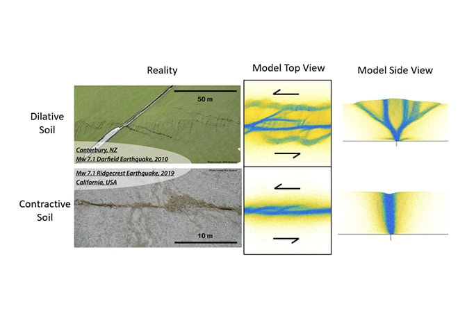
Simulations represented the physical models that use sand or clay in a box with a movable base to visualize tectonic deformations on a manageable scale. The researchers subjected virtual soils with loose, medium-dense and dense packing densities to bedrock strike-slip displacements, where tectonic plates move horizontally past one another.
“Surface fault rupture during earthquakes can threaten communities and infrastructure, but the physics that control how shallow shear zones form and evolve remain poorly understood. These simulations give us a controlled yet realistic environment where we can directly explore how the physical properties of soils and sediments near a fault influence how rupture develops at the ground surface,” said Curtis Baden, a research geophysicist at the USGS Earthquake Science Center and contributing author of the study.
The researchers found that looser soil, which contracts during shearing, confines deformation to a narrower area that propagates vertically above the bedrock fault. Denser soil expands during shearing and produces more widespread deformation with multiple separate ruptures propagating in different directions. The packing density of the soil was the only difference between simulations that exhibited these different soil behaviors. The simulations further showed how very complex soil behaviors and rupture patterns can emerge from simple physics.
“We thought that our observations of complex surface fault rupture patterns in nature must result from very complex soil profiles and geologic histories. But we observed such complex patterns even with very simple homogeneous soil profiles and simple displacement boundary conditions. These simulations demonstrate that much of the rupture complexity in nature actually comes from the principles of contraction and dilation in soil mechanics and geotechnical engineering,” said Garcia.
The researchers confirmed the realism offered by the discrete element method by showing how the simulation results matched previous physical model experiments. Taking it a step further, they compared their simulations with surface fault ruptures from two real earthquakes—the 2010 Darfield earthquake in New Zealand and the 2019 Ridgecrest earthquake in California.
The simulation results were consistent with the real-world occurrences. Broader zones of deformation with multiple distinct ruptures occurred in New Zealand, an area with coarser-grained soils. More localized damage occurred in finer-grained soil in California.
As a next step, the research team would like to add more complexity to simulations to more closely represent nature. Currently, the simulation focuses on frictional interactions between particles, but does not include bonding and cementation that could be present in rocky, clayey and much older soil deposits.