Flying Into hurricanes to save lives
Gus Alaka (BSE CLaSP ‘08) chases storms with NOAA.
Gus Alaka (BSE CLaSP ‘08) chases storms with NOAA.
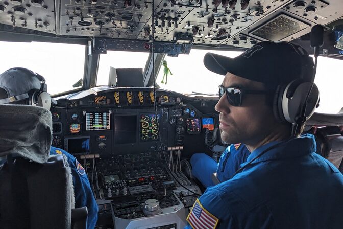
Two things were on Ghassan Alaka’s (BSE CLaSP ’08) mind as he flew into the eye of Hurricane Dorian in August 2019. Where would the storm make landfall? And would his family’s home in Miami be in its path?
Alaka has flown on more than 100 hurricane hunter flights since he joined the National Oceanic and Atmospheric Administration (NOAA) Atlantic Oceanographic & Meteorological Laboratory’s Hurricane Research Division in 2014. He became its director in 2024.
The hours-long flights can be harrowing, as hurricane-force winds can jolt the plane hundreds of feet at a time. But despite the turbulence, Alaka stays focused on collecting the data that’s essential for accurately forecasting hurricanes.
“We know that collecting these data sets that you can’t get anywhere else is literally saving lives,” Alaka said. “If you were to take away all the hurricane data that we’ve collected from the forecasting models, their accuracy would degrade by 20%. And even incremental changes can affect millions of people because the forecasts determine who is included in evacuation orders.”
Alaka’s flight into Dorian was one of 16 that NOAA’s hurricane hunter team made to gather data that would help them predict the storm’s path. As the plane cut through the storm, two radar dishes on its tail made 3D maps of the hurricane. The team also dropped cylindrical sensors called dropsondes at strategically selected locations, sliding them down chutes that led through an airlock and then out the belly of the plane. About the size of a water bottle, the devices drop through a hurricane on parachutes, measuring air temperature, pressure and humidity.
On hurricane hunter flights, the data from dropsondes and from the plane’s radar is transmitted to a ground station, screened for errors and sent to the National Hurricane Center and National Weather Service to inform storm forecasts.
The data helps the National Hurricane Center predict the path of hurricanes and issue warnings to help residents in affected areas stay safe. Over the years, it has also become a valuable resource that meteorologists like Alaka can study to improve future hurricane forecasts. Computer simulations that crunched the data from Dorian, for example, showed that the jetstream was a key factor that pushed the storm away from Florida.
Based on those findings, Alaka authored a study suggesting that monitoring large-scale features in the atmosphere can help predict a hurricane’s path and that comparing results from several simulations can help forecasters determine where to take measurements.
In 2024, those techniques helped forecasters predict the path of Hurricane Helene more quickly. NOAA was able to warn the public that Helene could develop into a major hurricane before it officially became a tropical storm, giving residents additional time to prepare.
“I think having that short distance between the research that we’re doing and real societal impacts is really motivating,” Alaka said.